
Walk a Montgomery County Street
A useful street directory search moves from geography to names, then back to source documents. Begin with one exact address in the Montgomery County Citizen Access Portal. The parcel card can supply the assessed owner, parcel or account key, situs address, map clues, value, and a deed reference. Keep the situs, which means the physical location, apart from the mailing address used for tax contact. Neither field lists a complete household.
- Search the house number and street in Citizen Access. Copy the parcel or account key, owner name, physical address, legal description, and deed clue that appear.
- Open the official county GIS and appraisal links. Locate the parcel, inspect its boundary, and move along the road one parcel at a time.
- Carry each exact owner name and deed reference to Probate Records & Recording. Search both sides of transfers rather than expecting a street-address search.
- For property within the City of Montgomery, request a permit, certificate of occupancy, code, inspection, zoning, or variance record by exact address when it answers the question.
- Use a reverse or criss-cross directory for an earlier listed occupant. Compare the directory date with deeds, census schedules, probate files, and newspapers.
This sequence keeps unlike facts from blending. The appraisal roll speaks to assessment and ownership. GIS fixes a parcel in space. A deed records a transfer. A directory can associate a listed adult with the address at publication time. The Montgomery County street directory becomes reliable only when the date and purpose of each source remain visible.
Montgomery Street Records by Address
Several official sources can illuminate the same address, but their coverage and access routes differ. The online property roll and map are the best current starting points. Probate's land index is keyed by party name or book and page, not promised as a street search. Older material requires a counter, public terminal, books, or microfilm. City files are requested by address and may carry category fees.
| Address source | What it can establish | Where to use it | Main limit |
|---|---|---|---|
| Parcel card | Assessed owner, situs, mailing address, value, map and deed clues | Revenue Commissioner Citizen Access or Appraisal counter | Ownership is not a resident list |
| County and city GIS | Parcel boundaries, nearby tracts, roads, address points, zoning context | Official web viewers | Maps do not identify all occupants |
| Recorded instruments | Grantor, grantee, instrument, indexed date, book and page | Probate index, terminal, books and microfilm | Computer index begins June 1970 |
| City permit and code files | Work, inspection, certificate, violation, zoning or variance tied to an address | City public-record request | Access and fees depend on the report |
| Reverse directories | A listed adult or business under a house number | Montgomery Room, County Archives and ADAH | Publication gaps and omissions remain |
VoterView does not fill the gaps in this table. It matches identifying details supplied by a registrant and can confirm that person's status, polling place, and address. It is not an open street roll. Historical voter and poll material may instead require the Alabama Department of Archives and History, county microfilm, or local election records.
Note: A missing online result should trigger a counter or archive check, not a claim that no Montgomery County record exists.
Search Montgomery County Parcel Fields
The Montgomery County street directory relies heavily on the Revenue Commissioner's current roll. Its official service describes assessments, property records, deeds, tax maps, taxes due, and payment functions. The live frame did not expose every advanced control during research, so only verified keys belong in a search plan. Do not assume an export tool, a ZIP filter, or a special result field that has not been seen.
| Verified search key | Input type | How it helps |
|---|---|---|
| Owner name | Text, alternative key | Finds the current assessed owner; try exact variants |
| Property or address | Text, alternative key | Retrieves a parcel from its house and street |
| Parcel or account | Text, alternative key | Returns the exact property after GIS supplies its key |
| Tax and payment functions | Links or actions | Places assessment and payment information beside the property record |
Read physical and tax-contact fields separately. A different mailing address can help distinguish records, but it does not prove where the owner lives. A homestead or exemption flag may support an owner-occupancy theory for its tax year. It still cannot name every person at the address.
Browse Montgomery Streets in GIS
GIS turns a single hit into a street-by-street view. Search or zoom to the starting parcel, check the parcel boundary against the road, then pan along the named street. Clicking adjacent shapes can reveal the account or parcel key needed back in Citizen Access. That method is stronger than guessing that every nearby roof or mailbox shares the same street name.
The City of Montgomery GIS service directory documents live services for Parcels, Roads, Streets and POI, address and neighborhood context, ZIP Code, Zoning, city council areas, and other layers. The screenshot below shows that official service catalog. It confirms the available geographic themes without turning a map layer into proof of residence.
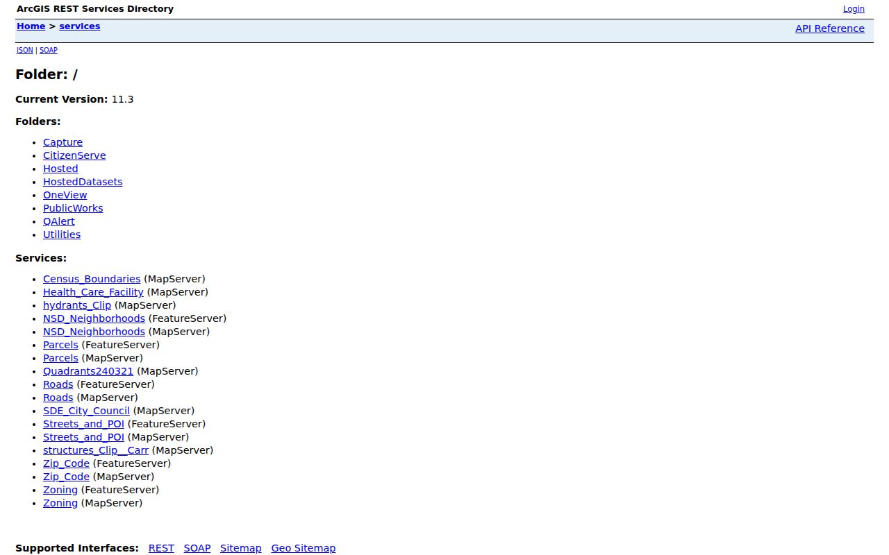
Parcel, road, ZIP, and zoning services help determine which public office has the next record. The mapped shape is the bridge between the postal address and the legal parcel, not a directory of people.
Note: The research did not verify a named buffer tool or every viewer control, so use visible search, zoom, and parcel-click functions only.
Decode Montgomery Address Terms
Four terms prevent most street directory errors. They explain why the address on a tax notice can differ from the land named in a deed and why an old directory may not match a modern map.
- Parcel
- A mapped tract and its database key. It is a unit of land, not a household.
- Situs address
- The physical location used by appraisal. It differs in purpose from the owner's tax mailing address.
- Plat
- A recorded map that divides land into lots, blocks, roads, or easements and helps tie a street address to a legal tract.
- Criss-cross directory
- A directory arranged by street and house number, often used to find a listed occupant when the address is known.
- Legal description
- The lot, block, subdivision, or metes-and-bounds wording that identifies land even when a road name changes.
Use the legal description as the stable thread. House numbers, postal labels, and city lines can shift. A legal description and deed reference let the Montgomery County address search continue through those changes.
Carry Montgomery Streets Into Probate
The Montgomery County Probate Records & Recording Division holds deeds, mortgages, judgments, liens, releases, and assignments. Its free computer index covers real property from June 1970 forward. Online document images require a $10 monthly account, and a printed online image costs $0.25. The Records Room at 101 South Lawrence Street has public terminals, deed-book images from book 400 forward, microfilm, and staff help. Counter copies are $1 per page, with $2 added for certification.
Start from the exact owner and deed clue on the parcel card. In the Probate search, enter the party as last name then first name without a comma. Date limits help with broad results. The gray plus expands a party to instrument rows, while book and page can open a known placement for an authorized image user. Check each likely spelling and each role in a transfer.
Index tip. Probate documents a percent-sign wildcard before letters, such as %hub, to catch fragments and possible indexing differences.
The access split is important. The index can identify an instrument for free, but the online image is paid. Public Records Room terminals bridge that gap. For a full named-street chain, repeat the assessor-to-Probate handoff parcel by parcel instead of trying to force a street query onto a party index.
Renamed Montgomery Street Evidence
West Jefferson Davis Avenue became Fred D. Gray Avenue by unanimous City Council action on October 5, 2021, followed by dedication on October 26. That verified change matters to any street directory search spanning the date. Earlier deeds, city directories, permits, maps, and newspaper references may use W. Jeff Davis Avenue, while current parcel and road systems use Fred D. Gray Avenue.
Search both names and preserve the source date. A later committee considered several other roads, but consideration does not prove that each was renamed. Never extend the verified Fred D. Gray Avenue history to Calhoun Road, Clanton Avenue, Cortez Street, De Soto Street, Early Avenue, or Jackson Street without a final official action for the road in question.
Legal descriptions, recorded plats, deed references, and the County's Land & Lot Book Archives can keep the chain intact when a street-name search fails. They also help with early entries expressed by corners, nearby landmarks, or intersections rather than a modern number.
Request Montgomery Records by Street
Within city jurisdiction, permits and certificates can date work at a property. Code, inspection, zoning, and variance reports can add a public applicant, owner, action, or case date when the record is open. No official historical permit-name browser was verified, so the dependable route is the City public-record request process with the exact address and a named record type.
Since April 7, 2025, the City lists at least $25 for routine reports, $75 for an assessment letter by address, and $25 per address and report for a certificate of occupancy, code violation, inspection, zoning, variance, or special-exception item. Extra pages are $1.50 per side, and complex work may require a 50 percent deposit. Wait for notice before sending payment.
The request requires a full physical address plus requester contact details. It may go in person, by mail, or by fax. Inspection hours are listed as Monday through Friday, 9 a.m. to 3 p.m. Receipt verification may take 10 business days, followed by up to 15 more for the department. First establish city jurisdiction with GIS, since a Montgomery postal label alone does not make the parcel a City property.
Note: A permit or code record dates an official action at the site; it does not establish who occupied every room at that time.
Read Past Montgomery Streets
Reverse directories supply the occupant layer that parcel rolls lack. Montgomery County Archives identifies cross-reference directories from about 1982 through 2008, and ADAH holds a Greater Montgomery, Prattville, and Wetumpka cross-reference run for 1993 through 1997 plus later editions. The Montgomery Room at the main library also holds city directories, microforms, yearbooks, and vertical files under restricted, noncirculating access.
These volumes can list an adult or business by address, but they are snapshots. A missing person may have moved between editions, been omitted, or lived in a household listed under someone else. A directory entry does not prove ownership. The full run, publishers, and entry-reading method belong on the Montgomery city directory collections page; here the reverse section serves one narrow role, matching a dated house number to a listed occupant.
For pre-1970 work, pair the directory with deed books and microfilm at Probate. ADAH maps, newspapers, church records, and county microfilm can extend the street story. The Montgomery Room and County Archives fill gaps when no stable online address index exists.
Montgomery Street Directory Limits
A street directory cannot reveal everyone who lives at an address. The property roll names an assessed owner, not all residents. A mailing address may be off site. VoterView is an identity-matched self-service tool, not a public block browser. Utility customer data, DMV addresses, protected voter addresses, juvenile records, sealed matters, and many private group rosters remain outside lawful street research.
Even public facts need context. A deed proves a recorded ownership act. A directory is a dated listing. GIS proves geography. Permit and code files document city actions. Keep the source name and date beside every note, and correct an error through the office that maintains the record.
Use records lawfully. Montgomery County address records support property, family, civic, and personal research. Never use them to stalk, threaten, harass, or evade a protected address.
Alabama law protects people from stalking and harassing communications. Public access does not cancel those rules. When current ownership is the goal, use the street chain. When the question shifts to one named person, use the Montgomery County resident lookup and require two independent facts before treating records as one identity.